Working Groups / Measuring and monitoring
Measurements of ground elevation, elevation changes and aquifer system compaction are pivotal to monitoring and characterising land subsidence processes. Several instruments and data analysis techniques enable such measurements from remote and/or on site. The selection of one or more of these approaches is driven by specific user requirements, such as the intended spatial and temporal scales of analysis, the necessary measurement precision and accuracy, and the component of the process that the user would like to investigate. Among the available approaches, there are:
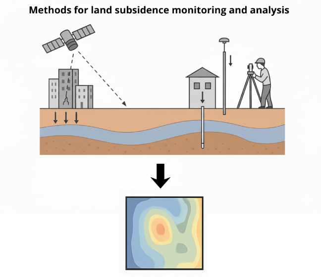
Geodetic surveying
includes leveling campaigns (geometric, or tacheometric) with spirit-levels, total stations, mobile GPS/GNSS, or the installation of one or more permanent stations operating continuously (cGPS), allowing for high precision measurements
Satellite interferometry (InSAR)
multi-temporal processing technique based on the analysis of radar images of the Earth’s surface captured from space, enabling the displacement estimation at ground and anthropogenic targets, with applicability ranging between the single-building to regional, national and even continental scales, and up to sub-millimeter precision on annual displacement rates
Borehole sensors
comprise extensometers, allowing aquifer system compaction measurements between the ground level and one or more benchmarks located at depth (up to several hundreds of meters below the ground surface); and fiber optics sensors, which can identify variations in physical parameters altering the properties of the fiber, including temperature, pressure, vibrations, and ground deformation
Members
-

Francesca Cigna (Coordinatore)
-

Federico Raspini (Coordinator)
Bibliography
- Cigna F., Esquivel Ramírez R., Tapete D. 2021. Accuracy of Sentinel-1 PSI and SBAS InSAR displacement velocities against GNSS and geodetic leveling monitoring data. Remote Sensing, 13, 4800. — link
- Gambolati G., Teatini P. 2021. Chapter 3. Measuring and Monitoring Subsidence and Compaction. In: Land subsidence and its mitigation. Guelph, Ontario, Canada, 92 pp. — link
- Ng A.H.-M., Ge L., Chang H.-C., Du Z. 2023. Geodetic monitoring for land deformation. Remote Sensing, 15, 283. — link
- Poland J.F.E., Yamamoto S., & Working Group 1984. Chapter 2. Field measurement of deformation. In: Poland J.F.E. Guidebook to studies of land subsidence due to groundwater withdrawal. International Hydrological Programme-WG 8.4, UNESCO, Paris, pp.17-35. — link
- Raspini F., Caleca F., Soldato M.D., Festa D., Confuorto P., Bianchini S. 2022. Review of satellite radar interferometry for subsidence analysis. Earth-Science Reviews, 235, 104239 — link