Working Groups / Subsidence and palaeo sea-level change
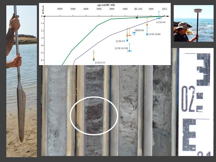
Assessment of amounts and rates of long-term subsidence and sediment compaction in coastal sedimentary environments can be obtained measuring the displacement of geological paleo sea-level indicators relative to modelled relative sea-level elevations. In coastal plains, geological indicators are represented by dated intertidal peat sediments. The misfit between measured and modelled palaeo sea-level elevation can be attributed to the combined effect of regional subsidence and local sediment compaction. This can be disentangled using dated intertidal peat unconformably resting on top of the coastal plain substrate. After being corrected for the effect of compaction, the misfit between measured and modelled relative sea-levels provides a quantitative assessment of local subsidence since each of the dated peat layer and present day.
Members
-

Matteo Vacchi (Coordinator)
-

Marta Pappalardo (Coordinatore)
-

Alessandro Chelli (Coordinator)
Bibliography
- Chelli A., Pappalardo M., Bini M., Brückner H., Neri G., Neri M., Spada G. (2017) - Assessing tectonic subsidence from estimates of Holocene relative sea level change: an example from the NW Mediterranean (Magra Plain, Italy). The Holocene, 27 (12), 1988-1999. doi:10.1177/0959683617715688
- Mattei G., Vacchi, (2023) - Geographic variability of the millennial sea-level changes along the coast of Italy. Alpine and Mediterranean Quaternary, 36 (1), 63-74.
- Pappalardo M., Chelli A., Bini M., Brückner H., Morigi C., Ragaini L. (2021) - On the role of sediment compaction and tectonic subsidence in relative sea-level reconstructions – a case study from the Apuo-Versilian coastal plain (NW Mediterranean). Geografia Fisica e Dinamica Quaternaria, 44, 159-172. DOI 10.4461/ GFDQ.2021.44.12
- Vacchi M., Marriner N., Morhange C., Spada G., Fontana A., Rovere A. (2016) - Multiproxy assessment of Holocene relative sea-level changes in the western Mediterranean: Sea-level variability and improvements in the definition of the isostatic signal. Earth-Science Reviews, 155, 172-197. doi: 10.1016/j.earscirev.2016.02.002
- van Asselen S., Stouthamer E., van Asch Th.W.J. (2009) - Effects of peat compaction on delta evolution: A review on processes, responses, measuring and modeling. Earth-Science Reviews, 92 (2009) 35–51.
- Shennan, I., Long A.J., Horton B.P. (2015) - Handbook of sea-level research. Wiley Blackwell, 581 pp. https://doi.org/10.1002/9781118452547.ch2